

FAO projects in Myanmar and the Philippines use technology to boost sustainability and resilience

04 JULY 2018, PAMPANGA, PHILIPPINES – A team of experts from the Department of Agricultire work together with Food and Agriculture Organization for the United Nations in using drones in gathering visual data on recently damaged rice crops in Magalang town in Pampanga province.
FA0/VEEJAY VILLAFRANCA
Unmanned Aerial Vehicles (UAV), otherwise known as drones, now play a key role in disaster recovery and development projects, including the monitoring of land and forests to ensure that they are used sustainably. ©FAO/Veejay Villafranca
In the last couple of years, we’ve seen the use of Unmanned Aerial Vehicles (UAV) – or drones, as most people know them – really take off. From enhancing video coverage of events to taking stock of the aftermath of natural disasters, they now have a key role to play in many different contexts. They’re even part of FAO’s strategy to tackle the recent desert locust outbreak in West Africa.
The possibilities with UAV technology are far-reaching, and FAO is harnessing this potential to monitor the use of natural resources and increase sustainability. UAVs save time, are cost efficient and provide up-to-date data and images in high resolution for many different purposes. They’re also easy to use, making them the perfect tool for experts and amateurs alike.


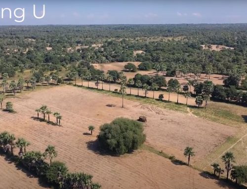
Left/top: UAV photos, like this one, can give an accurate view of land use from above. ©FAO/Xavier Bouan
Right/bottom: A young boy in Chin state Myanmar enjoys seeing his village through UAV goggles. ©FAO/Xavier Bouan
So how is FAO utilising UAVs to protect our planet’s resources and people’s livelihoods?
1. Monitoring deforestation and land degradation
Deforestation and land degradation are major problems but ones that are often hard to see and monitor. Some 129 million hectares of forest – an area almost equivalent in size to South Africa – have been lost since 1990. This works out to a loss of 23 hectares of forest per minute! Additionally, 12 million hectares of land are degraded each year. Deforestation and land degradation damage biodiversity, hurt livelihoods and increase the risks from extreme weather, ultimately increasing poverty and hunger and at times forcing local communities to migrate.
In Myanmar, FAO is using UAVs as part of a project to monitor the use of forests and land to ensure that they are used sustainably. With forests covering over 48 percent of the country, it is almost impossible to know and monitor the situation from the ground, making it difficult to implement the right policies. UAVs, conversely, offer a broader, birds-eye-view of forests, making it easier to capture the current situation and allow authorities to monitor their use, protecting these precious resources from over-exploitation.
When it comes to tackling land degradation, UAVs have a similar role to play. Though local communities often know the situation on the ground, evidence is needed to share with the government and enable them to implement policies. Previously, this information was gathered manually, travelling the land on foot to assess the situation and report back. But with forests covering such vast areas, it is almost impossible to get an accurate picture this way. UAV photos and videos highlight the land condition from above, easily providing the necessary evidence to make informed decisions.
2. Mapping and planning land use
In order to accurately monitor forests and land degradation, Land Use and Land Cover (LULC) maps are fundamental. These maps demonstrate the various types of land, how they are being used and how this use changes over time. LULC maps are mainly developed through satellite imagery, alongside manual ground checking. However, photos taken by drones have now become an important third step, helping check and improve datasets and increase the accuracy of assessments. Myanmar has now implemented UAVs for its land use planning and sustainable land management.
UAVs also encourage involvement from the local community. UAV goggles allow people on the ground to see what the UAV sees, bringing the situation to life for local inhabitants and encouraging them to use land more sustainably.

An FAO expert gathers visual data on recently damaged rice crops in the town of Magalang in the Philippines. ©FAO/Veejay Villafranca
3. Assessing the effects of natural disasters
The Philippines ranks fourth among the world’s most disaster-prone countries. Between 2018-2019, 21 typhoons hit the country. The rapid assessment of damages is vital to start the rebuilding process. However, the conventional method of manual assessments can often take months and may lead to inaccuracies. This lengthy process can result in farmers receiving recovery support too late or may lead to some areas being left behind. But since 2015, FAO and the Philippines Department of Agriculture have been working together to use UAVs to efficiently assess agricultural damage after a natural disaster.
After a successful FAO pilot programme using UAVs in pre- and post-disaster assessments, the Philippines government has dramatically improved its response capacity. For example, in early 2019, an El Niño event led to a significant drought, affecting crops countrywide. Thanks to the continuing expansion and improved use of UAVs, however, the Department of Agriculture had already deployed UAVs to the area and was able to confirm which crops were struggling for water and where they were located. By not having to assess the situation in person, the government saved time and resources. It also meant that field personnel and technical staff could exchange information and analyse the situation more easily, allowing them to provide help more quickly and better allocate resources.
UNFAO · TZH 07 – Drones, data, food security: How UAVs offer new perspectives on agriculture
Building a sustainable planet for future generations is impossible without innovation. In many projects around the world, FAO, hand-in-hand with countries, is solving age-old agricultural problems with new technology and fresh approaches. UAVs are just one of the technologies that can help us to modernise and scale up innovation across the agricultural sector, building a more sustainable planet for everyone.
source: http://www.fao.org/fao-stories/article/en/c/1323066/